Key Advantages
Business-Aligned WeatherSphere: Precision Visualization & Alerts
-

High-Res Weather Grid
High-Res Weather Display & Forecasting
Global high-precision grid weather service with kilometer-level spatial resolution and minute-level temporal precision, delivering real-time insights into hyper-local weather dynamics.
-

Dynamic Weather Visualization
Global Weather Intelligence: All Elements, One View
Featuring 10+ meteorological parameters including wind fields, precipitation, temperature and air pressure. Delivers real-time visualization, interactive local weather data retrieval, and dynamic forecasting visualizations across space and time.
-

Accurate Forecasting Models
Live Monitoring, Pro Forecast
Powered by advanced models including WRF, Data Easy has developed specialized forecasting and severe weather warning systems for localized regions.
-

Easy Historical Query
All-Space-Time Weather Intelligence
Access sub-second retrieval of vast historical weather data by location, empowering insurance providers to swiftly identify historical risk zones and enabling real-time risk management and claims decision-making.
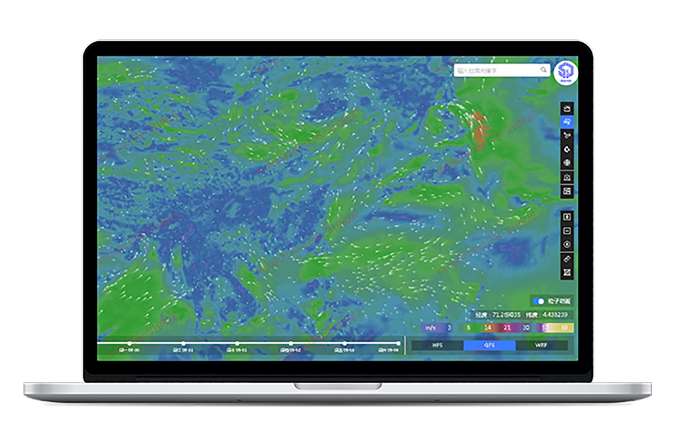
Worldwide Kilometer-Level Live Weather Monitoring
Kilometer-Scale Precision
Data Easy delivers kilometer-scale high-precision grid weather services, surpassing traditional county-level forecasting in both granularity and geographical relevance.Minute-Level Alerts
High-stability parallel notifications for meteorological risks—including heavy rain, extreme heat, drought, and floods—enable timely extreme weather response and significantly reduce organizational risk exposure.Daily Billion-Point Updates
Processes over 1 billion weather data points daily with real-time dynamic updates for the latest meteorological insights.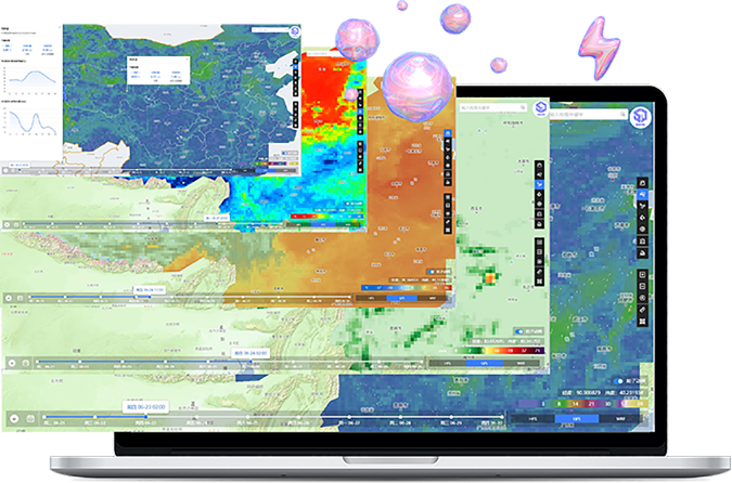
Multiple Weather Parameters, Dynamic Single-Map Visualization
10+ Meteorological Elements
Wind, rain, snow, temperature, humidity, air pressure, and more—meeting cross-industry weather monitoring needs.Interactive Unified Weather Map
A visually dynamic map displays nationwide trends, linking weather risks to operational geography. Click anywhere to retrieve local data and statistical charts—all weather dynamics on one screen.Weather Changes Dynamic Visualized
Animated forecast visualization tracks weather movements across space and time, enabling proactive risk management and operational readiness.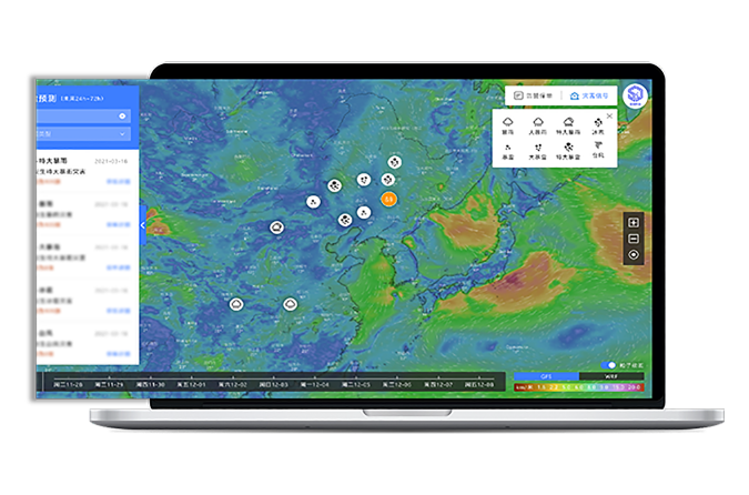
WRF-Enhanced Forecasting with Proprietary Models
10 Integrated Parameters
Integrates multi-source data—GFS, HFS, WRF, XZ, national forecasts, and Doppler radar—enhancing prediction accuracy across critical weather factors.Advanced Self-Developed Models
Built on the global WRF framework, Data Easy's proprietary regional forecasting and severe weather models deliver precision outperforming comparable solutions.10-Day Weather Forecast
Provides high-accuracy weather predictions beyond 10 days with kilometer-scale grid refinement for reliable forward planning.
Past, Present & Future: Complete Weather Mastery Trillion-Scale & Real-Time
Our grid-based system stores trillion-level meteorological data, enabling sub-second querying of historical, real-time, and forecast weather information by location. This supports rapid identification of historical risk zones and empowers government and enterprise users with spatiotemporal data-intelligent management for weather risk prevention and control.

Operational Weather Risk Monitoring: Real-Time Sharing, Seamless Collaboration
Build a professional weather service system within your organization to enable efficient, high-frequency monitoring of critical assets—including major projects, infrastructure, farmland, buildings, and historical natural disaster risk zones. Through a unified platform, achieve instant multi-department data sharing and coordinated response workflows.
Application Scenarios
Property Insurance
Agricultural Disaster Reduction
Commodities & Futures

In property insurance, insurance companies bear compensation for losses caused by natural disasters or accidents to large targets such as projects, buildings, and farmland. Through Remote Sensing Application Platform, insurance companies can use massive remote sensing images to achieve efficient, real-time, and widely covered spatial monitoring of such targets, and retrieve historical spatiotemporal information, helping insurance companies significantly reduce risk costs and achieve organizational business digital intelligence transformation and upgrading.
- High-precision gridded weather data services
- High-precision gridded weather prediction and minute-level weather disaster early warning
- Multi-type weather one map dynamic visualization
- Real-time query of massive historical weather data based on place names and addresses

Weather factors such as rainfall, drought, floods, and extreme weather have a great impact on crops and can cause serious economic losses. Agricultural management departments, agricultural companies, etc. can use Weather Watch Platform to conduct high-precision real-time weather dynamic monitoring of farmland, orchards, etc., and share weather real-time, weather disaster early warning and monitoring through the cloud, predict natural disaster risks in advance, efficiently coordinate prevention among multiple departments, and reduce economic losses caused by extreme weather.
- Provide multi-type weather dynamic one map for regional agriculture, intuitively grasp the spatial relationship between farmland, orchards and weather disasters
- Digital middle platform spatiotemporal informatization upgrade, multiple business departments share massive weather data
- Historical weather risk area analysis, key monitoring and protection

Data Easy's high-resolution weather platform enables precise monitoring of agricultural growing conditions, supply chain volatility, and extreme climate impacts. With kilometer-scale forecasting and real-time risk alerts, financial institutions and traders gain actionable insights into crop yield forecasts, inventory exposure, and price fluctuations—supporting data-driven hedging, risk modeling, and investment decisions across soft and hard commodity markets.
- Development of weather disaster plans based on precision weather forecasting
- Grid-based fine management of weather disaster emergencies
- Key monitoring of historical weather risk areas
Ready to Get Started?
Our solution consultant will contact you within 1 business day
Or call our service hotline
+86 512 6726 6068 / +86 181 3696 0617