Industry Trends
Watershed "Air-Space-Ground" Collaborative Monitoring and Perception System, Supporting Digital Twin Data Foundation Construction, Supporting Watershed Flood Defense Intelligent Scheduling
Developing new quality productive forces in water conservancy is a prerequisite for building a water conservancy powerhouse and achieving water conservancy modernization. The construction of digital twin water conservancy systems is an important path for cultivating new quality productive forces in water conservancy and promoting high-quality development of water conservancy. The watershed "air-space-ground" collaborative monitoring and perception system is the foundation of smart water conservancy digital twins. Remote sensing platforms, in scenarios of multi-source massive remote sensing and spatiotemporal data aggregation, provide foundation support capabilities for monitoring and perception, providing "computing data", "algorithms" and "computing power" for Agriculture digital twins.
-

Multi-source Aggregation Challenges, Data Management Mode Bottlenecks
Under traditional management modes, multi-source massive remote sensing data has not been centrally, standardly, and uniformly managed. Not only is data storage scattered and difficult to access, but it also brings challenges to subsequent processing, analysis, distribution and sharing. Data is constrained by management modes and cannot fully play its role on the business side, reducing overall system efficiency and making it difficult to achieve the "four predictions" goals.
-

Data Functions Not Integrated, Data Channels Blocked
Agriculture requires data channels to be unimpeded, real-time and fast. The professionalism of remote sensing data makes its management, processing, analysis, application, and distribution functional links fragmented. Data functions are not integrated, requiring processing across multiple software platforms, online and offline, unable to form a real-time automated integrated "production line", blocking data channels that support the data foundation.
-

Data Processing and Interpretation Process Not Smooth, Flood Control Scheduling Low Timeliness
Under traditional remote sensing processing modes, to cope with different needs and changes in water conservancy flood control business, data needs repeated preprocessing, patch interpretation, water body change extraction, etc., and the mapping process is complex, requiring a large amount of manual operation. Computing resources cannot be dynamically allocated, resulting in data real-time and precision unable to meet the needs of business application precision and refinement, making it difficult to support the timeliness requirements of monitoring and early warning business applications in watershed flood defense.
Data Easy Solution
Self-developed Domestic Platform Aggregates Multi-source Massive Remote Sensing, Cloud-native Full Lifecycle Centralized Management
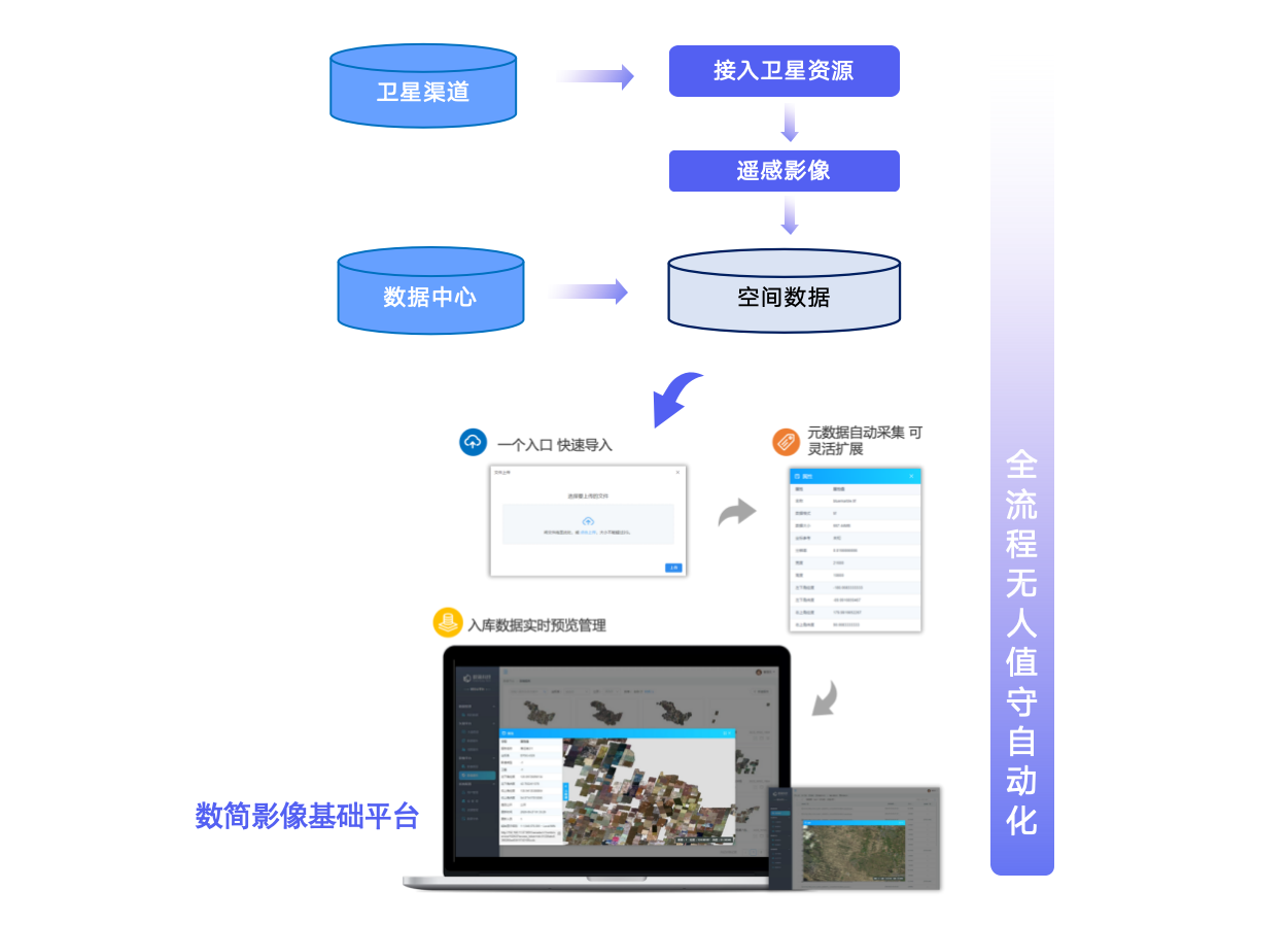
Data Real-time Automated Channels, Throughout Processing, Analysis, Sharing and Application Full Chain
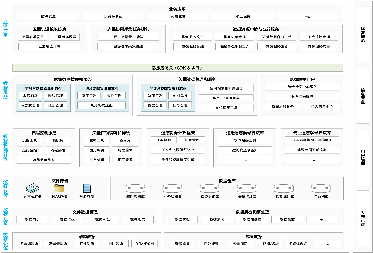
Data Easy, targeting the difficulties in multiple links of "collection, production, management, and application" of water conservancy remote sensing spatiotemporal big data, based on self-developed spatiotemporal platform, provides capabilities covering multi-source satellite remote sensing and drone images "overall planning, multi-source aggregation, intelligent processing, management and distribution, comprehensive application, service sharing", for Agriculture remote sensing application needs, full-domain massive image data management and publishing, opening up water conservancy remote sensing resource channels, supporting efficient digital twin water conservancy data foundation construction; achieving full chain from processing and analysis to sharing and application of massive multi-source heterogeneous data, efficiently and accurately processing remote sensing data, real-time intelligent analysis and calculation, empowering "business side" with "data side" benefits.
Solution Advantages
-
One Platform Unified Standard Management of Multi-source Spatiotemporal Data
One platform unified "network disk" style management of multi-source spatial data such as satellites, aircraft, drones, radar, scientific datasets, etc., and establishes unified data standards, builds continuous data resource aggregation and update mechanisms; massive data can be flexibly queried and retrieved through semantic and spatiotemporal composite retrieval modes, covering the full process from remote sensing data reception, real-time decompression, upload, cataloging, quality inspection, storage, publishing, and application.
-

One Platform Remote Sensing Data Full Lifecycle Function Integration
One platform achieves full lifecycle links and professional functions of multi-source satellite remote sensing and drone images, for Agriculture remote sensing application needs, full-domain massive image data management, processing, publishing, analysis, and application, supporting water conservancy remote sensing resource channel opening and efficient digital twin water conservancy data foundation construction.
-
One Platform Remote Sensing Processing Intelligent Interpretation Process Automation
For the diversity and timeliness of watershed flood defense business, Data Easy's remote sensing data real-time online dynamic processing core technology, combined with remote sensing intelligent computing framework, remote sensing interpretation algorithm model library and process orchestration professional modules, dynamically meets diverse business needs, providing foundation support capabilities for "data management - query display - analysis calculation - element interpretation - resource services".
-
Platform Built-in General and Water Conservancy Professional Remote Sensing Interpretation Algorithm Library
Platform algorithm library built-in includes general remote sensing interpretation functions such as optical water bodies, radar water bodies, buildings, forest land, dam bodies, vegetation, etc., as well as water conservancy professional remote sensing algorithm libraries such as flood obstacle patch interpretation function, inundation range interpretation function, building quantity statistics in flood-prone areas, water area shoreline remote sensing monitoring, surface change remote sensing monitoring, etc., combined with other professional modules of the platform, achieving smooth integrated application of "data source access → processing → analysis → patches → mapping", efficiently extracting remote sensing information.
Value Scenarios & Customer Cases
City Key Flood Control Project - Digital Twin Construction Project Remote Sensing Platform
For remote sensing application needs such as municipal water conservancy business supervision, water conservancy flood control project supervision and flood emergency response, establishes a comprehensive remote sensing platform integrating "overall planning, multi-source aggregation, intelligent processing, management and distribution, comprehensive application" of remote sensing image data, supporting water conservancy remote sensing resource channel opening and efficient digital twin water conservancy data foundation construction: achieving full chain from processing and analysis to sharing and application of massive multi-source heterogeneous data, providing real-time precise quantitative remote sensing information for watershed flood defense decision-making.
- Water conservancy remote sensing resource channel opening
- Water conservancy remote sensing tool empowerment
- Water conservancy AI remote sensing application empowerment
Flood Storage and Detention Area Smart Inspection Management - Remote Sensing Intelligent Interpretation Platform
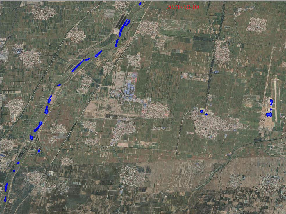
The platform supports using multi-source massive satellite remote sensing images to conduct daily interpretation and monitoring of water body range and movement speed in flood storage and detention areas, aggregates and integrates processing of data such as photos, videos, panoramic images, orthophoto maps collected by drones, providing strong support for scientific management of flood storage and detention areas, embankment defense, etc.
- Remote sensing image dynamic on-demand real-time processing
- Remote sensing intelligent computing framework, dynamic computing power configuration
- General and water conservancy professional remote sensing interpretation algorithm library
- Process orchestration platform, algorithm process customization
Provincial Water Conservancy - Small Reservoir Flood Control Scheduling Project (Abbreviation)
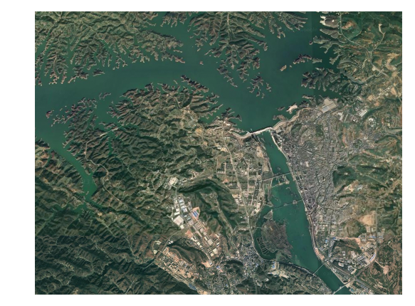
For more than 1,000 small reservoirs in a province, implementing flood control scheduling project, through technical means such as automatic measurement and reporting of rainfall and water conditions, digital management of reservoir information, rain capacity analysis and watershed joint scheduling pre-rehearsal, providing timely and accurate information for safe operation and flood control scheduling of small reservoirs, assisting leadership decision-making, doing a good job in reservoir safety management, and ensuring good operation of reservoirs. Data Easy, through the foundation platform, provides collaborative support capabilities for high-performance and high-standard data foundation for multi-source massive spatiotemporal data aggregation, management, analysis, and services of the flood control scheduling project.
- Multi-source spatiotemporal data non-tiling real-time publishing
- Image non-tiling real-time publishing
- Vector data efficient retrieval and reading
- Terrain data tiling-free publishing and management
Get Agriculture Field Spatiotemporal Solution Now
Welcome to call our service hotline
+86 512 6726 6068 / +86 181 3696 0617
or mail us
sales@shujiantech.com