The Challenge
New Tech, Old Barriers: Free Your Data Flow
Rapid advances in Earth observation, satellite remote sensing, and UAV technologies are bottlenecked by outdated data systems. Processing limitations and preprocessing demands hurt timeliness and quality; inconsistent standards and isolated tools limit sharing; while storage and talent gaps stall integration and efficiency.
-

Slow Release Cycles, Low Timeliness
Traditional image publishing requires days to weeks of preprocessing. Single high-resolution scenes take hours to process, failing to meet emergency response needs.
-

Inconsistent Standards, Complex Management
Missing metadata, mixed coordinate systems, and fragmented data require standardization. Complex single-user desktop tools hinder sharing and collaboration across teams.
-
Limited Processing Power, High Compute Demands
Legacy systems lack parallel computing, forcing repeated tiling for different uses. This limits real-time analysis, multi-device support, and integrated 2D/3D visualization.
Data Easy Solution
End-to-End Cloud Platform for Massive Imagery
We empower government agencies, satellite firms, and drone developers with a PB-scale cloud solution for automated production, real-time publishing, online processing, and flexible analysis of multi-source remote sensing data. Our platform enables cross-department collaboration, streamlines workflows by 90%, and offers a user-friendly interface for non-experts—boosting observation responsiveness and making geospatial data management simpler and more cost-effective.
Advantages
-
Slice-Free Real-Time Publishing
Platform's dynamic processing engine requires no preprocessing or tiling, enabling "publish-on-ingestion" capability. Data production cycles shrink from days to minutes, boosting emergency response. Satellite center case shows 90% faster publishing with automated TB-scale processing.
-

Unified Multi-Source Data Management
Standardized interfaces and cloud-native architecture integrate heterogeneous data (satellite, vector, weather), resolving metadata gaps and coordinate conflicts. Unified service APIs enable logically centralized management of distributed data, simplifying operations.
-
High-Performance Parallel Computing
Core "Data Easy Engine" supports real-time processing of billions of data points using just 1/10 the hardware of legacy systems. Dynamic storage optimization enhances I/O efficiency for pixel-level processing, reducing computing demands.
-

Flexible Multi-Platform Support
Unified 2D/3D services adapt to all devices without reprocessing. Supports full-resolution viewing and API integration through a one-platform-to-many model, multiplying cross-department collaboration efficiency.
Scenarios & Cases
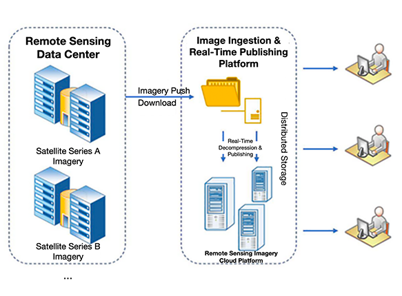
Automated Data Production & Publishing
Unattended Satellite Imagery Reception & Real-Time Publishing System
As a central data hub receiving terabytes of daily satellite data, the client previously relied on manual operations with high labor and time costs. Data Easy implemented a streamlined "Remote Sensing Cloud Platform" that automates daily downloads from satellite centers, auto-scans data, and performs real-time decompression, upload, cataloging, publishing, and application (L1A-DOM)—enabling fully automated, unattended operation. Integrated with production workflows, it dynamically optimizes imaging pipelines, shortening data production cycles by 90% and reducing operational costs by 70%.
- Multi-source satellite imagery support with real-time monitoring and instant publishing
- Publish imagery without preprocessing or tiling using configurable rules
- Automatically optimize production plans by connecting imaging workflows
- Centralized management with clear visibility into all image assets
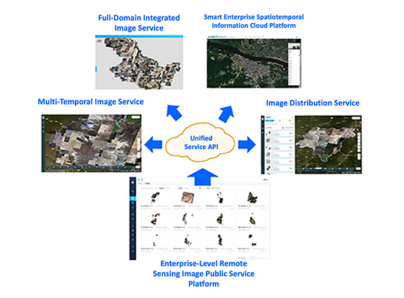
Data as a Service
On-Demand, Real-Time Public Remote Sensing Data Services
A satellite center provides daily multi-source remote sensing imagery and geospatial data services to government agencies, enterprises, and the public, meeting diverse application needs. Through its foundational platform capabilities, Data Easy empowers the client to achieve cloud-based centralized management and real-time flexible distribution of massive remote sensing and spatial data—serving hundreds of thousands of users with online public cloud services and subscription platforms. This establishes a PaaS platform built around the data center, enabling one set of remote sensing imagery to support multiple service applications efficiently.
- Unified management of multi-source, multi-temporal imagery
- Slice-free rapid publishing services
- Restful API interface services
- Full-resolution online smooth browsing
- Public cloud environment data services
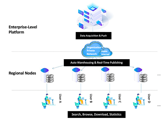
Hardware-Software Integration
Building a "Remote Sensing Box"
An organization responsible for establishing and managing fundamental geospatial databases—acquiring, storing, managing, and maintaining various remote sensing spatial data while providing accessible data services to multiple business units—partnered with Data Easy. Leveraging our spatiotemporal digital platform, we helped build a cross-regional, multi-department, and multi-level remote sensing service system. This enables centralized management and distribution of imagery data, with regional and operational nodes seamlessly accessing shared data through an integrated "Remote Sensing Box", establishing an interconnected, cross-regional remote sensing service architecture.
- Ready-to-Use & Reliable Hardware-Software Integration
- Real-Time Updates & Automated Publishing
- Multi-Temporal Data Storage & Automated Format Processing
- Efficient Spatiotemporal Search & Full-Resolution Cross-Platform Viewing
Get Satellite/Surveying & Mapping/Geospatial Center Solution Now
Welcome to call our service hotline
+86 512 6726 6068 / +86 181 3696 0617
or mail us
sales@shujiantech.com