Key Advantages
PB-Scale, Multi-Source Remote Sensing Data Platform
-

Multi-Source Imagery
Satellite & drone data integration
Supports 100+ mainstream satellite data types, multiple coordinate systems, projections, and formats—including multispectral, hyperspectral, and DEM data.
-

Real-Time Automation
Instant processing & publishing
Imagery is published upon acquisition, with dynamic conversion across hundreds of projection systems. An automated data pipeline enables real-time sharing, viewing, management, analysis, and application—building a real-time public service system for geospatial data.
-

Centralized Management
Unified data orchestration
A logically centralized platform integrates imagery assets across devices, sources, and time phases. Manage intermediate and final spatiotemporal data through one interface and one platform.
-

Developer-Friendly
Flexible APIs & SDKs
Real-time computation and dynamic processing of remote sensing data—including dynamic stretching and RPC correction—with support for domain-specific models and flexible development via Web API and JS API.
Storage & Production
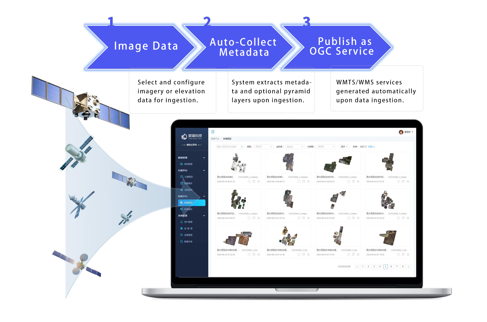
PB-Scale Satellite Data: Auto-Produced, Real-Time&Instant Sharing
Support for 100+ Satellite Data Types
Optical satellites: Landsat, MODIS, CBERS, QuickBird, WorldView, IKONOS, GeoEye, SPOT 6/7, Pleiades; Radar: Radarsat, ERS, COSMO, TerraSAR-X, ENVISAT, Sentinel-1. Supports multiple coordinate systems, projections, formats – multispectral, hyperspectral, elevation data, and pyramid generation.Automated Spatial Data Production
End-to-end unmanned workflow: rules-based automation from reception to publishing. Includes real-time decompression, upload, cataloging, publishing, and application, with intelligent metadata parsing and quality validation.Real-Time Organizational Imagery Sharing
Tile-free service model for rapid publishing of satellite, elevation, and UAV data. Reduces PB-scale data update cycles from weeks to hours, enabling government and enterprises to build efficient cloud platforms with global, all-weather, real-time geospatial services.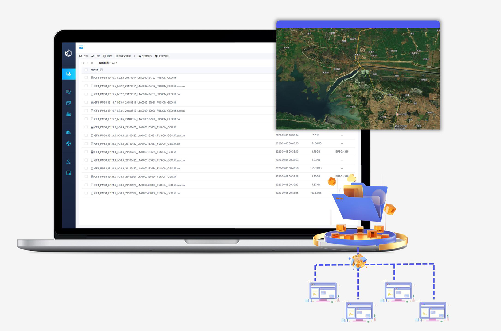
Management & Sharing
Unified Data Hub: Access Everywhere, Manage as One
Multi-Type Spatiotemporal Data – Unified Management
The platform integrates data across devices, sources, time phases, and processing stages. Manage imagery assets without pre-ingestion through a single interface, with multi-dimensional filtering and clear visibility of data distribution.Unified Platform & Flexible Services
A single platform supports efficient, adaptable data services for raw imagery, tiles, and metadata. Download data in any format or custom clip area—including original, mosaicked, or tiled raster data. Publish one dataset simultaneously as multiple OGC-standard services.Petabyte-Scale Data Management
Manages up to hundreds of petabytes of imagery, supporting distributed storage and real-time cloud sharing for hundreds of millions of images.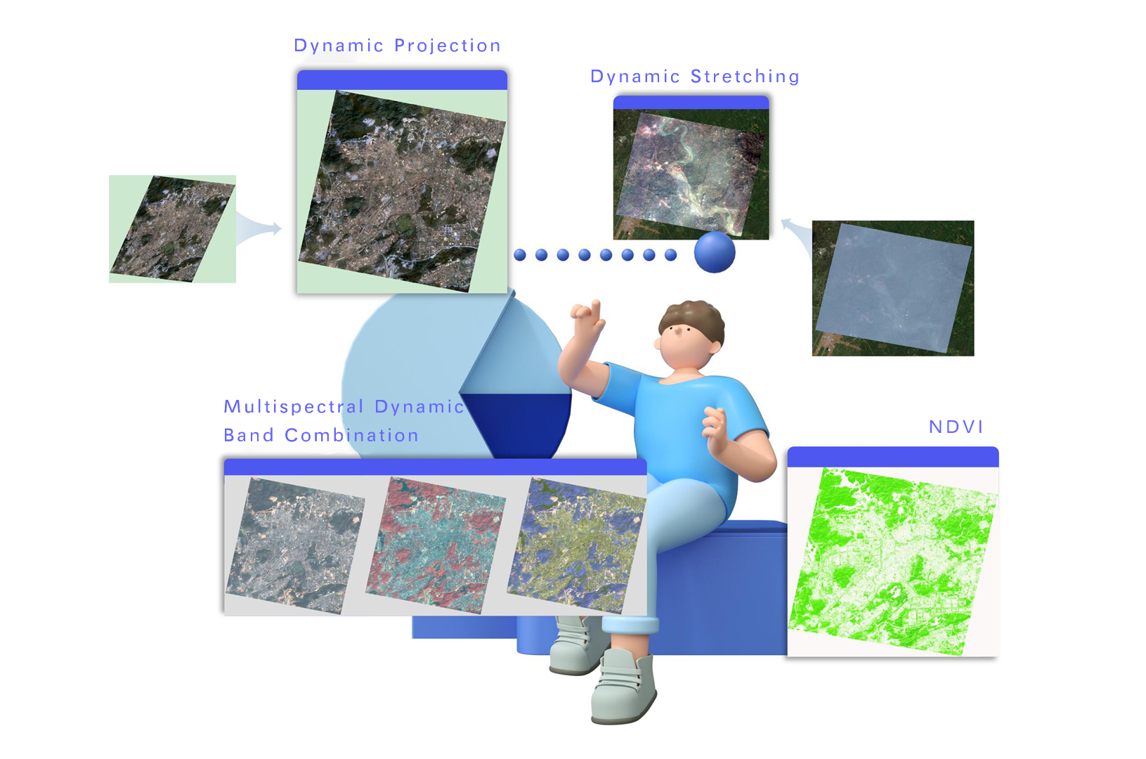
Processing & Application
Live Imagery, Dynamic Processing, Ready-to-Build
Real-Time Computation & Online Collaboration
Enable real-time processing methods during data publishing and support multi-department collaboration for dynamic remote sensing data processing and algorithm invocation. Build automated monitoring applications based on user servers.Dynamic Stretching, Projection & RPC Correction
Apply dynamic stretching enhancement to non-8-bit data; support dynamic projection across coordinate systems with user-defined seven parameters; perform dynamic correction for multispectral and panchromatic imagery using satellite RPC files.Unified Development
Flexible development via Web API and JS API. Developers can access various spatiotemporal data services and processing capabilities through these interfaces, with differentiated data access for different user types. The JS API features a unified design for both mobile and desktop applications.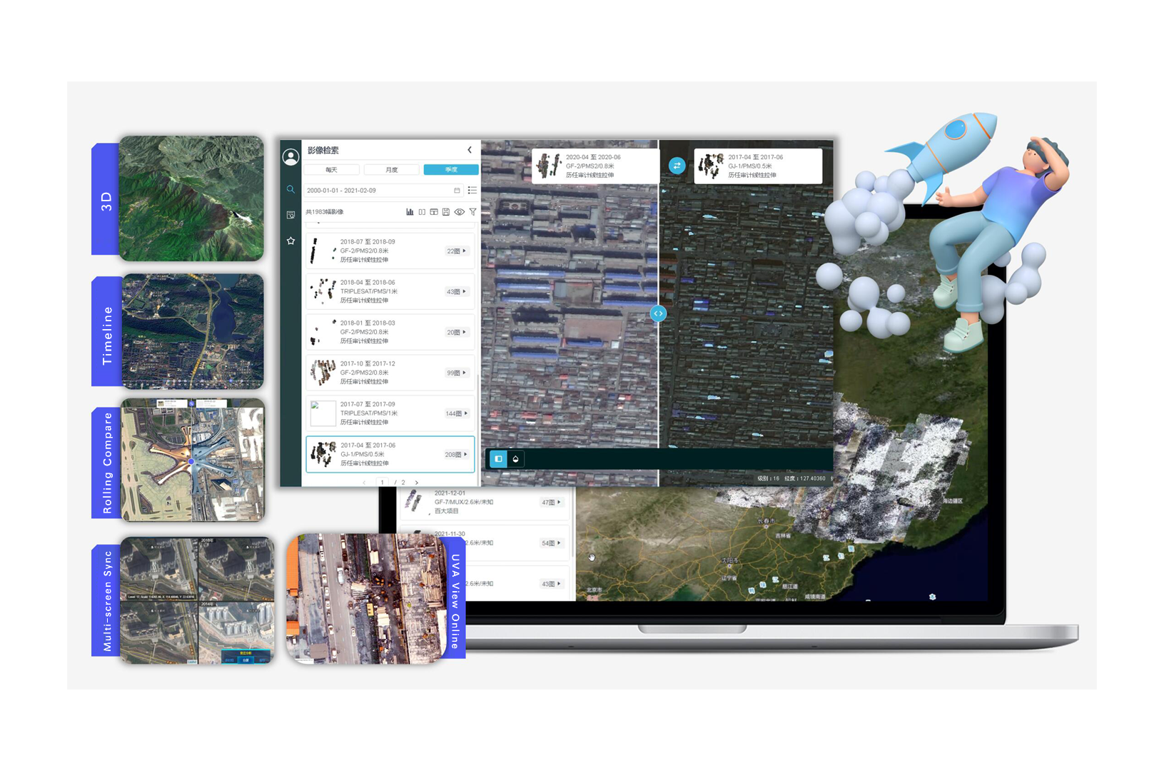
Query & Browse
Geo-Interactive Search, Full-Res Viewing: Your Imagery, Any Device
Geo-Interactive Search & Analysis
Explore imagery through map-based queries with smart filtering by resolution and sensor. Compare multi-temporal data via swipe tools and synchronized multi-screen viewing.Multi-Dimensional Full-Res Online Exploration
Full-resolution satellite and drone imagery view online, in real time, across desktop, mobile, and large-screen displays.Perform change detection with multi-temporal analysis and tailored visualization workflows.Integrated Monitoring & Custom Applications
Combine drone and satellite imagery with 10-minute correction cycles. Access specialized tools including multispectral viewing, dynamic projection, and real-time rendering.
Microservices & Dockerized
Dynamic Storage Architecture: For Demanding Workloads
Cloud Security & One-Click Deployment
Featuring Docker-based rapid deployment and scaling, the platform supports standalone, cluster, private, public, and hybrid cloud environments with one-click setup and frontend-backend separation.High-Performance Engine & Storage
Powered by a C/C++ core engine, it publishes GB-scale data in minutes and PB-scale data in hours. Compatible with DAS, SAN, NAS, HDFS, OBS, and hybrid storage for dynamic resource allocation and sustained peak performance.Smart Caching & High Concurrency
Delivers fast response under high concurrency with intelligent hot-data caching and background tile caching for optimized image data access.
Application Scenarios
Data Center
Agricultural Monitoring
Pipeline Inspection

Earth observation systems and continuous geospatial data flows are reshaping data management paradigms. The Data Easy platform delivers real-time publishing, centralized management, and adaptive application capabilities—enabling automated ingestion, processing, and distribution of multi-satellite data. This establishes a dynamic, multi-level service network that ensures efficient data asset governance across the organization.
- Centralized Management & Distribution: Supports high-performance distribution of up to 20TB of daily remote sensing data across subsidiaries and multi-tiered organizational nodes.
- Cross-Role Data Services: Distributes standardized or specialized image products through one platform to internal functions—including data scientists, domain experts, and operational teams.
- Business-Focused Imaging Solutions: Delivers flexible imagery support to various business units, enabling scientific decision-making across diverse operational scenarios.
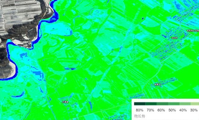
Leveraging satellite imagery through preprocessing, vegetation index calculation, and retrieval algorithms, our platform enables comprehensive analysis of agricultural conditions. The Data Easy platform delivers real-time processing of massive multi-source satellite data, seamless algorithm integration, and one-click result publishing—supporting dynamic monitoring of soil moisture, crop growth, and field health while enabling efficient collaboration among agricultural departments, research institutes, and farm management teams.
- Dynamic coordinate and projection transformations
- Adaptive stretching and RPC correction
- Hyperspectral band combination and vegetation index computation
- Real-time color rendering with super-resolution layers
- Online remote sensing retrieval and real-time analysis

Intelligent Pipeline Integrity Management Leveraging efficient satellite and drone imagery processing and fusion, the Data Easy platform enables a comprehensive pipeline integrity management system. It reconstructs integrated 2D/3D geographic scenes spanning hundreds of kilometers across varied terrains, while high-speed drone image correction significantly improves inspection frequency and efficiency. Combined with AI-powered change detection, it rapidly identifies environmental changes along the right-of-way—such as third-party intrusion or natural hazards—and pinpoints their locations. After timely repairs are completed, field reports can be uploaded directly into the system, closing the loop in a streamlined safety workflow.
- Full-Coverage 2D/3D Map
- Smart End-to-End Inspection
- Disaster Alert Map
- Emergency Response Map
Ready to Get Started?
Our solution consultant will contact you within 1 business day
Or call our service hotline
+86 512 6726 6068 / +86 181 3696 0617